
Thank you for supporting this site ❤️
Make a donation
Make a donation
Le Poteau topographic map
Click on the map to display elevation.
Thank you for supporting this site ❤️
Make a donation
Make a donation
About this map
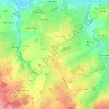
Name: Le Poteau topographic map, elevation, terrain.
Average elevation: 322 m
Minimum elevation: 267 m
Maximum elevation: 384 m
Thank you for supporting this site ❤️
Make a donation
Make a donation
Other topographic maps
Click on a map to view its topography, its elevation and its terrain.
23350
France > Nouvelle-Aquitaine > Creuse > Genouillac > Le Moulin des Fougères
Average elevation: 327 m