
Thank you for supporting this site ❤️
Make a donation
Make a donation
Lake Eildon topographic map
Click on the map to display elevation.
Thank you for supporting this site ❤️
Make a donation
Make a donation
About this map
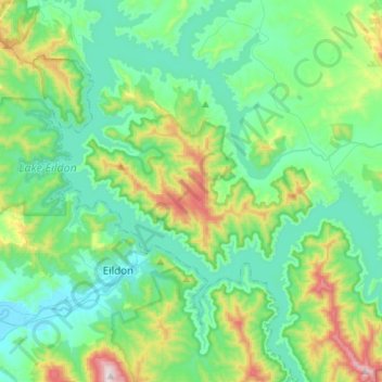
Name: Lake Eildon topographic map, elevation, terrain.
Location: Lake Eildon, Shire of Mansfield, Victoria, Australia (-37.26399 145.84523 -37.11169 146.11800)
Average elevation: 386 m
Minimum elevation: 203 m
Maximum elevation: 1,029 m
Thank you for supporting this site ❤️
Make a donation
Make a donation
Other topographic maps
Click on a map to view its topography, its elevation and its terrain.