
Thank you for supporting this site ❤️
Make a donation
Make a donation
Sines topographic map
Click on the map to display elevation.
Thank you for supporting this site ❤️
Make a donation
Make a donation
About this map
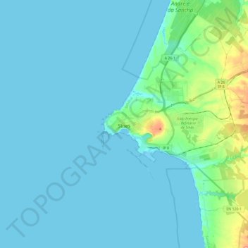
Name: Sines topographic map, elevation, terrain.
Location: Sines, Setúbal, Portugal (37.86578 -8.89392 38.04929 -8.68144)
Average elevation: 16 m
Minimum elevation: 0 m
Maximum elevation: 136 m
Thank you for supporting this site ❤️
Make a donation
Make a donation
Other topographic maps
Click on a map to view its topography, its elevation and its terrain.
Thank you for supporting this site ❤️
Make a donation
Make a donation
Thank you for supporting this site ❤️
Make a donation
Make a donation
Thank you for supporting this site ❤️
Make a donation
Make a donation
Thank you for supporting this site ❤️
Make a donation
Make a donation
Charneca de Caparica
Portugal > Setúbal > Charneca de Caparica e Sobreda > Charneca de Caparica
Average elevation: 40 m
Thank you for supporting this site ❤️
Make a donation
Make a donation