
Vermillion topographic map
Interactive map
Click on the map to display elevation.
About this map
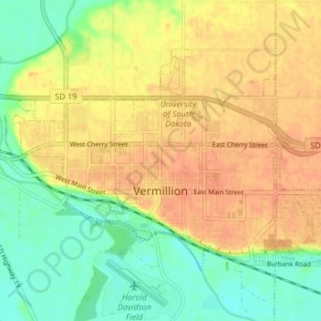
Name: Vermillion topographic map, elevation, terrain.
Average elevation: 366 m
Minimum elevation: 343 m
Maximum elevation: 384 m
The elevation of the city is 1,221 feet (372 m).
Other topographic maps
Click on a map to view its topography, its elevation and its terrain.
Wakonda
United States > South Dakota > Clay County
Wakonda, Star Township, Clay County, South Dakota, United States
Average elevation: 422 m
Meckling Township
United States > South Dakota > Clay County
Meckling Township, Clay County, South Dakota, United States
Average elevation: 354 m
Vermillion
United States > South Dakota > Clay County > Vermillion
Vermillion, Clay County, South Dakota, 57069, United States
Average elevation: 379 m