
Gunung Sinabung topographic map
Interactive map
Click on the map to display elevation.
About this map
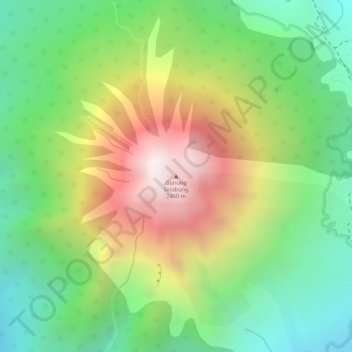
Name: Gunung Sinabung topographic map, elevation, terrain.
Location: Gunung Sinabung, Karo, North Sumatra, Indonesia (3.17090 98.39200 3.17100 98.39210)
Average elevation: 1,835 m
Minimum elevation: 1,393 m
Maximum elevation: 2,428 m
Other topographic maps
Click on a map to view its topography, its elevation and its terrain.
Kampung Merdeka
Indonesia > North Sumatra > Karo
Kampung Merdeka, Karo, North Sumatra, Sumatra, 22153, Indonesia
Average elevation: 1,468 m
Berastagi
Indonesia > North Sumatra > Karo
Berastagi, Karo, North Sumatra, Indonesia
Average elevation: 1,418 m