
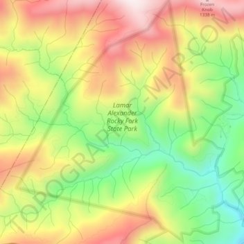
Lamar Alexander Rocky Fork State Park topographic map
Interactive map
Click on the map to display elevation.
About this map
Name: Lamar Alexander Rocky Fork State Park topographic map, elevation, terrain.
Average elevation: 1,006 m
Minimum elevation: 665 m
Maximum elevation: 1,351 m
Other topographic maps
Click on a map to view its topography, its elevation and its terrain.
Flag Pond
United States > Tennessee > Unicoi County
Flag Pond, Unicoi County, East Tennessee, Tennessee, 37657, United States
Average elevation: 846 m
Unaka Springs
United States > Tennessee > Unicoi County
Unaka Springs, Unicoi County, East Tennessee, Tennessee, 37650, United States
Average elevation: 680 m
Erwin
United States > Tennessee > Unicoi County
Erwin, Unicoi County, Tennessee, 37650, United States
Average elevation: 599 m
Marbleton
United States > Tennessee > Unicoi County > Unicoi > Marbleton
Marbleton, Unicoi, Unicoi County, Tennessee, 37692, United States
Average elevation: 639 m
Pleasant Garden
United States > Tennessee > Unicoi County > Pleasant Garden
Pleasant Garden, Unicoi County, Tennessee, United States
Average elevation: 1,195 m
Unicoi
United States > Tennessee > Unicoi County
Unicoi, Unicoi County, Tennessee, United States
Average elevation: 709 m