
Thank you for supporting this site ❤️
Make a donation
Make a donation
Alexandria topographic map
Click on the map to display elevation.
Thank you for supporting this site ❤️
Make a donation
Make a donation
About this map
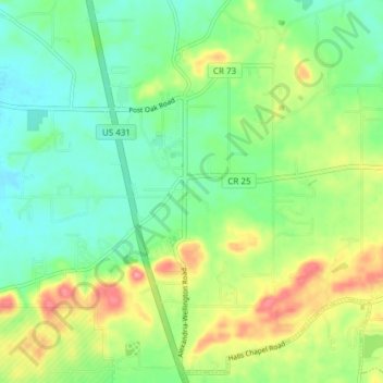
Name: Alexandria topographic map, elevation, terrain.
Location: Alexandria, Calhoun County, Alabama, 36250, United States (33.73876 -85.92260 33.79881 -85.84700)
Average elevation: 188 m
Minimum elevation: 155 m
Maximum elevation: 247 m
Thank you for supporting this site ❤️
Make a donation
Make a donation
Other topographic maps
Click on a map to view its topography, its elevation and its terrain.
Choccolocco State Forest
United States > Alabama > Calhoun County > White Plains
Average elevation: 322 m
Piedmont
United States > Alabama > Calhoun County
Dugger Mountain, the second highest peak in Alabama with an elevation of 2,140 feet (650 m), is located just outside the city limits of Piedmont, which is the closest city to the peak and wilderness area.
Average elevation: 263 m
Thank you for supporting this site ❤️
Make a donation
Make a donation
Thank you for supporting this site ❤️
Make a donation
Make a donation
Thank you for supporting this site ❤️
Make a donation
Make a donation
Thank you for supporting this site ❤️
Make a donation
Make a donation