
Thank you for supporting this site ❤️
Make a donation
Make a donation
Champbenoist topographic map
Click on the map to display elevation.
Thank you for supporting this site ❤️
Make a donation
Make a donation
About this map
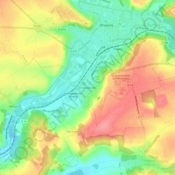
Name: Champbenoist topographic map, elevation, terrain.
Average elevation: 120 m
Minimum elevation: 77 m
Maximum elevation: 165 m
Thank you for supporting this site ❤️
Make a donation
Make a donation
Other topographic maps
Click on a map to view its topography, its elevation and its terrain.
Parc de la Porte du trou au chat
France > Île-de-France > Seine-et-Marne > Provins > Ville-haute
Average elevation: 125 m