
Thank you for supporting this site ❤️
Make a donation
Make a donation
Dimbhe topographic map
Click on the map to display elevation.
Thank you for supporting this site ❤️
Make a donation
Make a donation
About this map
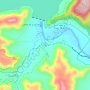
Name: Dimbhe topographic map, elevation, terrain.
Location: Dimbhe, Ambegaon, Maharashtra, India (19.06490 73.72529 19.10490 73.76529)
Average elevation: 755 m
Minimum elevation: 648 m
Maximum elevation: 996 m
Thank you for supporting this site ❤️
Make a donation
Make a donation
Other topographic maps
Click on a map to view its topography, its elevation and its terrain.