
Oberes Sudelfeld topographic map
Interactive map
Click on the map to display elevation.
About this map
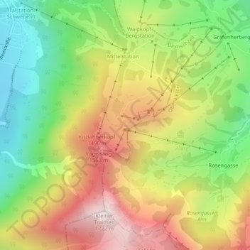
Name: Oberes Sudelfeld topographic map, elevation, terrain.
Average elevation: 1,216 m
Minimum elevation: 795 m
Maximum elevation: 1,702 m
Other topographic maps
Click on a map to view its topography, its elevation and its terrain.
Geitau
Deutschland > Bayern > Landkreis Miesbach > Bayrischzell
Geitau, Bayrischzell, Landkreis Miesbach, Bayern, 83735, Deutschland
Average elevation: 924 m