
San Francisco Javier topographic map
Interactive map
Click on the map to display elevation.
About this map
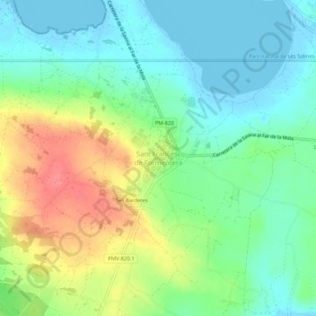
Name: San Francisco Javier topographic map, elevation, terrain.
Location: San Francisco Javier, Formentera, Islas Baleares, 07860, España (38.68540 1.40844 38.72540 1.44844)
Average elevation: 24 m
Minimum elevation: -4 m
Maximum elevation: 69 m
Other topographic maps
Click on a map to view its topography, its elevation and its terrain.
Formentera
España > Islas Baleares > Formentera > Formentera
Formentera, Islas Baleares, España
Average elevation: 7 m