
Guci topographic map
Interactive map
Click on the map to display elevation.
About this map
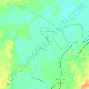
Name: Guci topographic map, elevation, terrain.
Location: Guci, Ujan Mas, Muara Enim, South Sumatra, Indonesia (-3.51572 103.71824 -3.50388 103.77293)
Average elevation: 33 m
Minimum elevation: 18 m
Maximum elevation: 64 m
Other topographic maps
Click on a map to view its topography, its elevation and its terrain.
Muara Lematang
Indonesia > South Sumatra > Muara Enim
Muara Lematang, Sungai Rotan, Muara Enim, South Sumatra, Indonesia
Average elevation: 5 m
Alai
Indonesia > South Sumatra > Muara Enim > Alai
Alai, Lembak, Muara Enim, South Sumatra, Indonesia
Average elevation: 16 m
Indramayu
Indonesia > South Sumatra > Muara Enim
Indramayu, Tanjung Agung, Muara Enim, South Sumatra, Indonesia
Average elevation: 326 m
Kota Padang
Indonesia > South Sumatra > Muara Enim > Kota Padang
Kota Padang, Semende Darat Tengah, Muara Enim, South Sumatra, Indonesia
Average elevation: 1,367 m