
Town Bank topographic map
Interactive map
Click on the map to display elevation.
About this map
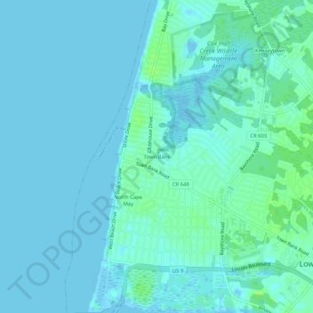
Name: Town Bank topographic map, elevation, terrain.
Average elevation: 3 m
Minimum elevation: -3 m
Maximum elevation: 11 m
Other topographic maps
Click on a map to view its topography, its elevation and its terrain.
Cold Spring
United States > New Jersey > Cape May County > Lower Township
Cold Spring, Lower Township, Cape May County, New Jersey, 08204, United States
Average elevation: 4 m
Tabernacle
United States > New Jersey > Cape May County > Lower Township
Tabernacle, Lower Township, Cape May County, New Jersey, 08204, United States
Average elevation: 5 m