
Bowling Green topographic map
Interactive map
Click on the map to display elevation.
About this map
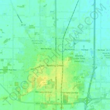
Name: Bowling Green topographic map, elevation, terrain.
Location: Bowling Green, Wood County, Ohio, United States (41.34884 -83.69860 41.41460 -83.59996)
Average elevation: 207 m
Minimum elevation: 201 m
Maximum elevation: 219 m
Other topographic maps
Click on a map to view its topography, its elevation and its terrain.
Pemberville
United States > Ohio > Wood County
Pemberville, Wood County, Ohio, United States
Average elevation: 200 m
Perrysburg
United States > Ohio > Wood County
Perrysburg, Wood County, Ohio, 43551, United States
Average elevation: 194 m
Rossford
United States > Ohio > Wood County
Rossford, Wood County, Ohio, 43460, United States
Average elevation: 191 m
Cygnet
United States > Ohio > Wood County > Cygnet
Cygnet, Wood County, Ohio, United States
Average elevation: 214 m