
Rath/Heumar topographic map
Interactive map
Click on the map to display elevation.
About this map
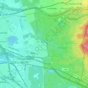
Name: Rath/Heumar topographic map, elevation, terrain.
Location: Rath/Heumar, Kalk, Köln, Nordrhein-Westfalen, 51107, Deutschland (50.91004 7.05848 50.94684 7.14535)
Average elevation: 65 m
Minimum elevation: 41 m
Maximum elevation: 133 m
Other topographic maps
Click on a map to view its topography, its elevation and its terrain.
Auweiler
Deutschland > Nordrhein-Westfalen > Köln > Auweiler
Auweiler, Köln, Nordrhein-Westfalen, 50765, Deutschland
Average elevation: 48 m
Roggendorf
Deutschland > Nordrhein-Westfalen > Köln
Roggendorf, Köln, Nordrhein-Westfalen, 50765, Deutschland
Average elevation: 44 m
Rodenkirchen
Deutschland > Nordrhein-Westfalen > Köln > Höningen
Rodenkirchen, Höningen, Köln, Nordrhein-Westfalen, 50997, Deutschland
Average elevation: 54 m