
Kuckberge topographic map
Interactive map
Click on the map to display elevation.
About this map
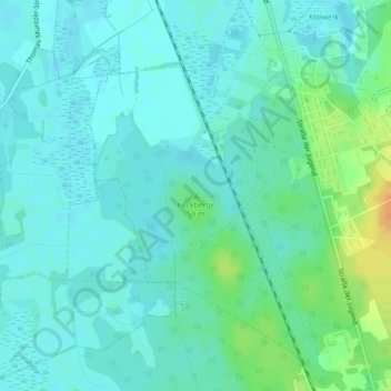
Name: Kuckberge topographic map, elevation, terrain.
Location: Kuckberge, Teltow-Fläming, Brandenburg, 15806, Deutschland (52.18687 13.44952 52.18697 13.44962)
Average elevation: 43 m
Minimum elevation: 35 m
Maximum elevation: 69 m
Other topographic maps
Click on a map to view its topography, its elevation and its terrain.
Mahlow
Deutschland > Brandenburg > Teltow-Fläming
Mahlow, Blankenfelde-Mahlow, Teltow-Fläming, Brandenburg, 15831, Deutschland
Average elevation: 45 m
Rangsdorf
Deutschland > Brandenburg > Teltow-Fläming
Rangsdorf, Teltow-Fläming, Brandenburg, 15834, Deutschland
Average elevation: 42 m
Stülpe
Deutschland > Brandenburg > Teltow-Fläming
Stülpe, Nuthe-Urstromtal, Teltow-Fläming, Brandenburg, Deutschland
Average elevation: 87 m
Trebbin
Deutschland > Brandenburg > Teltow-Fläming > Trebbin
Trebbin, Teltow-Fläming, Brandenburg, 14959, Deutschland
Average elevation: 42 m
Klein Schulzendorf
Deutschland > Brandenburg > Teltow-Fläming > Trebbin > Klein Schulzendorf
Klein Schulzendorf, Trebbin, Teltow-Fläming, Brandenburg, 14959, Deutschland
Average elevation: 41 m