
Netherwood topographic map
Interactive map
Click on the map to display elevation.
About this map
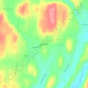
Name: Netherwood topographic map, elevation, terrain.
Average elevation: 110 m
Minimum elevation: 63 m
Maximum elevation: 170 m
Other topographic maps
Click on a map to view its topography, its elevation and its terrain.
Timothy Heights
United States > New York > Dutchess County > Town of Pleasant Valley
Timothy Heights, Town of Pleasant Valley, Dutchess County, New York, 12569, United States
Average elevation: 87 m
Salt Point
United States > New York > Dutchess County > Town of Pleasant Valley
Salt Point, Town of Pleasant Valley, Dutchess County, New York, 12578, United States
Average elevation: 97 m