
Thank you for supporting this site ❤️
Make a donation
Make a donation
Mount Coot-tha topographic map
Click on the map to display elevation.
Thank you for supporting this site ❤️
Make a donation
Make a donation
Mount Coot-tha
It is often claimed that Mount Coot-tha is the "highest point in Brisbane", but, as the elevations above show, the peak known as Mount Coot-tha is not even the highest peak of the mountain as a whole with both Constitution Hill and The Summit being higher. However, Mount Coot-tha has a lookout with unobscured views over much of Brisbane, while Constitution Hill and The Summit do not. Further to the west, there are even higher peaks within the City of Brisbane, such as.
Thank you for supporting this site ❤️
Make a donation
Make a donation
About this map
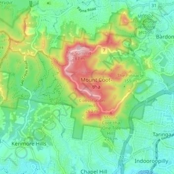
Name: Mount Coot-tha topographic map, elevation, terrain.
Average elevation: 88 m
Minimum elevation: 4 m
Maximum elevation: 278 m
Thank you for supporting this site ❤️
Make a donation
Make a donation
Other topographic maps
Click on a map to view its topography, its elevation and its terrain.
Thank you for supporting this site ❤️
Make a donation
Make a donation
Thank you for supporting this site ❤️
Make a donation
Make a donation
Thank you for supporting this site ❤️
Make a donation
Make a donation
Thank you for supporting this site ❤️
Make a donation
Make a donation