
Make a donation
Cadiz topographic map
Click on the map to display elevation.
Make a donation
About this map
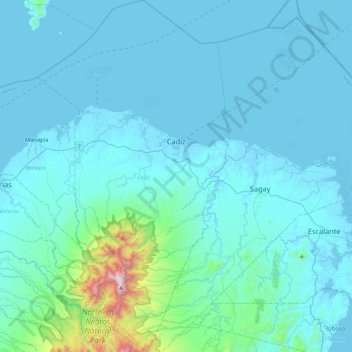
Name: Cadiz topographic map, elevation, terrain.
Average elevation: 116 m
Minimum elevation: -2 m
Maximum elevation: 1,504 m
Make a donation
Other topographic maps
Click on a map to view its topography, its elevation and its terrain.
Make a donation
Make a donation
Make a donation
Make a donation
Make a donation
Make a donation
Make a donation
Mount Kanlaon
Philippines > Negros Occidental > La Castellana
Kanlaon, also known as Mount Kanlaon and Kanlaon Volcano (Hiligaynon: Bolkang Kanglaon; Cebuano: Bolkang Kanglaon; Filipino: Bulkang Kanlaon), is an active stratovolcano and the highest mountain on the island of Negros in the Philippines, as well as the highest point in the Visayas, with an elevation of 2,465…
Average elevation: 1,920 m
Make a donation
Make a donation
Make a donation
Himamaylan City Public Plaza
Philippines > Negros Occidental > Himamaylan > Barangay Ⅲ
Average elevation: 5 m
Make a donation
Make a donation
Make a donation
Make a donation
Make a donation
Make a donation
Make a donation
Make a donation
Make a donation
Make a donation
Make a donation
Make a donation
Kanlaon
Philippines > Negros Occidental > La Carlota
Kanlaon, also known as Mount Kanlaon and Kanlaon Volcano (Hiligaynon: Bolkang Kanglaon; Cebuano: Bolkang Kanglaon; Filipino: Bulkang Kanlaon), is an active andesitic stratovolcano and the highest mountain on the island of Negros in the Philippines, as well as the highest peak in the Visayas, with an elevation…
Average elevation: 1,959 m
Make a donation
Make a donation
Make a donation