
Thank you for supporting this site ❤️
Make a donation
Make a donation
Chaves topographic map
Click on the map to display elevation.
Thank you for supporting this site ❤️
Make a donation
Make a donation
About this map
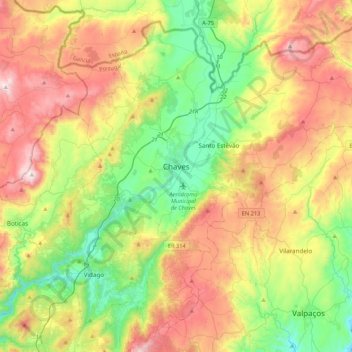
Name: Chaves topographic map, elevation, terrain.
Location: Chaves, Vila Real, Portugal (41.58127 -7.62056 41.88001 -7.19295)
Average elevation: 629 m
Minimum elevation: 268 m
Maximum elevation: 1,161 m
Thank you for supporting this site ❤️
Make a donation
Make a donation
Other topographic maps
Click on a map to view its topography, its elevation and its terrain.
Cidadelha de Jales
Portugal > Vila Real > Vila Pouca de Aguiar > Alfarela de Jales
Average elevation: 783 m
Thank you for supporting this site ❤️
Make a donation
Make a donation
Soutelinho do Monte
Portugal > Vila Real > Vila Pouca de Aguiar > Vreia de Bornes
Average elevation: 577 m
Thank you for supporting this site ❤️
Make a donation
Make a donation
Thank you for supporting this site ❤️
Make a donation
Make a donation
Thank you for supporting this site ❤️
Make a donation
Make a donation
Ribeira de Pena
Portugal > Vila Real > Ribeira de Pena (Salvador) e Santo Aleixo de Além-Tâmega > Ribeira de Pena
Average elevation: 570 m
Thank you for supporting this site ❤️
Make a donation
Make a donation