
Make a donation
Ottoschwanden topographic map
Click on the map to display elevation.
Make a donation
Ottoschwanden
Freiamt liegt im Mittleren Schwarzwald in 255 bis 744 Meter Höhe. Auf dem Gemeindegebiet befindet sich der 744 Meter hohe Hünersedel.
Make a donation
About this map
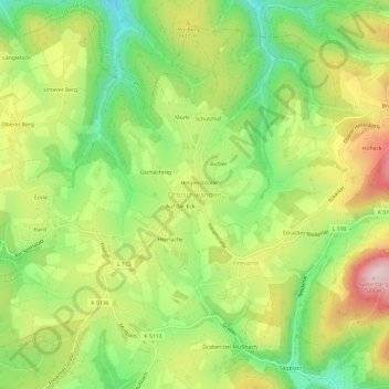
Name: Ottoschwanden topographic map, elevation, terrain.
Average elevation: 409 m
Minimum elevation: 262 m
Maximum elevation: 592 m
Make a donation
Other topographic maps
Click on a map to view its topography, its elevation and its terrain.
Elzach
Deutschland > Baden-Württemberg > Landkreis Emmendingen
Die Stadt liegt am östlichen Rand des Gebiets des Landkreises Emmendingen und grenzt dort an den Ortenaukreis und den Schwarzwald-Baar-Kreis. Topografisch ist das Gemeindegebiet durch seine Lage im Tal der Elz um den Hausberg Rohrhardsberg herum gekennzeichnet. Sie gehört zum Naturpark Südschwarzwald.
Average elevation: 606 m
Emmendingen (Kernstadt)
Deutschland > Baden-Württemberg > Landkreis Emmendingen > Emmendingen
Die Stadt liegt im Breisgau zwischen der Vorbergzone des Schwarzwaldes und dem Kaiserstuhl in der Rheinebene im Norden der so genannten Freiburger Bucht am Fluss Elz in 189 bis 403 Meter Höhe.
Average elevation: 242 m
Make a donation
Waldkirch
Deutschland > Baden-Württemberg > Landkreis Emmendingen
Die Stadt liegt an der Elz im südwestlichen Teil des Schwarzwaldes. Die Nachbargemeinden im Elztal taleinwärts sind Freiamt und Gutach im Breisgau, im südöstlich abzweigenden Simonswälder Tal Simonswald. Gemarkungsgrenzen bestehen zudem zu St. Peter und Glottertal. Talauswärts grenzt Waldkirch an…
Average elevation: 449 m
Simonswald
Deutschland > Baden-Württemberg > Landkreis Emmendingen
Der lang gestreckte, mehrkernige Ort Simonswald umfasst nahezu die gesamte gut besiedelbare Talfläche entlang der Wilden Gutach. Abgesehen vom Oberlauf wird deren Tal als Simonswälder Tal bezeichnet. Es mündet bei Gutach im Breisgau in das Tal der Elz. Von hier verläuft die Hauptstraße des Ortes über 17…
Average elevation: 740 m
Make a donation
Emmendingen
Deutschland > Baden-Württemberg > Landkreis Emmendingen
Die Stadt liegt im Breisgau zwischen der Vorbergzone des Schwarzwaldes und dem Kaiserstuhl in der Rheinebene im Norden der so genannten Freiburger Bucht am Fluss Elz in 189 bis 403 Meter Höhe.
Average elevation: 248 m
Altsimonswald
Deutschland > Baden-Württemberg > Landkreis Emmendingen > Simonswald
Average elevation: 664 m
Make a donation
Make a donation
Suggental
Deutschland > Baden-Württemberg > Landkreis Emmendingen > Waldkirch
Average elevation: 336 m
Siensbach
Deutschland > Baden-Württemberg > Landkreis Emmendingen > Waldkirch
Average elevation: 543 m
Make a donation
Jechtingen
Deutschland > Baden-Württemberg > Landkreis Emmendingen > Sasbach am Kaiserstuhl
Average elevation: 201 m
Emmendingen-Wasser
Deutschland > Baden-Württemberg > Landkreis Emmendingen > Emmendingen
Average elevation: 212 m
Obersimonswald
Deutschland > Baden-Württemberg > Landkreis Emmendingen > Simonswald
Average elevation: 784 m
Make a donation
79361
Deutschland > Baden-Württemberg > Landkreis Emmendingen > Sasbach am Kaiserstuhl
Average elevation: 189 m
Wildgutach
Deutschland > Baden-Württemberg > Landkreis Emmendingen > Simonswald
Average elevation: 842 m
Make a donation
Biederbach
Deutschland > Baden-Württemberg > Landkreis Emmendingen
Die Streusiedlungsgemeinde Biederbach liegt im Tal des südsüdostwärts laufenden Biederbaches und seiner Zuflüsse, der am Westrand der benachbarten Stadt Elzach in die Elz mündet. Das Haupttal beginnt auf Höhen um 660 m etwa zweieinhalb Kilometer nordöstlich des Hünersedels (744 m) bei…
Average elevation: 532 m
Mundingen
Deutschland > Baden-Württemberg > Landkreis Emmendingen > Emmendingen
Average elevation: 285 m
79331
Deutschland > Baden-Württemberg > Landkreis Emmendingen > Teningen (Kernort)
Average elevation: 218 m
Make a donation
Windenreute
Deutschland > Baden-Württemberg > Landkreis Emmendingen > Emmendingen
Average elevation: 259 m
79312
Deutschland > Baden-Württemberg > Landkreis Emmendingen > Emmendingen > Emmendingen (Kernstadt) > Windenreute
Average elevation: 255 m
Make a donation
Gutach im Breisgau
Deutschland > Baden-Württemberg > Landkreis Emmendingen
Die erstmalige urkundliche Erwähnung Gutachs findet sich im Jahr 1309 in einem topografischen Wörterbuch als Guota. 1316 kam Gutach zusammen mit Bleibach in den Besitz der Schwarzenberger auf der Kastelburg, Siegelau zu jenen auf der Schwarzenburg. Von einer Kapelle in Gutach wurde erst 1699 berichtet.
Average elevation: 479 m
Broggingen
Deutschland > Baden-Württemberg > Landkreis Emmendingen > Herbolzheim
Average elevation: 262 m
Oberprechtal
Deutschland > Baden-Württemberg > Landkreis Emmendingen > Elzach
Die Stadt liegt am östlichen Rand des Gebiets des Landkreises Emmendingen und grenzt dort an den Ortenaukreis und den Schwarzwald-Baar-Kreis. Topografisch ist das Gemeindegebiet durch seine Lage im Elztal um den Hausberg Rohrhardsberg herum gekennzeichnet. Sie gehört zum Naturpark Südschwarzwald.
Average elevation: 685 m
Make a donation
Freiamt
Deutschland > Baden-Württemberg > Landkreis Emmendingen
Freiamt liegt im Mittleren Schwarzwald in 255 bis 744 Meter Höhe. Auf dem Gemeindegebiet befindet sich der 744 Meter hohe Hünersedel.
Average elevation: 441 m
Endingen am Kaiserstuhl
Deutschland > Baden-Württemberg > Landkreis Emmendingen
Nur alle drei Jahre findet der „Alemannische Brotmarkt“ in der Endinger Altstadt statt. Hier bieten Bäcker und Genusshandwerker aus Baden, dem Elsaß, Vorarlberg und der Schweiz ihre Brotspezialitäten an Marktständen feil. Höhepunkt des Brotmarkts ist der Festumzug am Sonntag, an dem sich die…
Average elevation: 238 m
Malterdingen
Deutschland > Baden-Württemberg > Landkreis Emmendingen
Die Jakobskirche ist unterschiedlichen Baustilen zuzuordnen. Chor und Seitenkapellen können in ihrer heutigen Form auf das Jahr 1517 datiert werden. Der geostete Turm wurde 1828 unter der Planung von Gottlieb Lumpp umgebaut und hat seitdem den typischen Pyramidendachstuhl im Weinbrennerstil. Mit einer Höhe…
Average elevation: 227 m
Make a donation
Bubenbad
Deutschland > Baden-Württemberg > Landkreis Emmendingen > Sasbach am Kaiserstuhl
Average elevation: 185 m
Make a donation
Sasbach am Kaiserstuhl
Deutschland > Baden-Württemberg > Landkreis Emmendingen
Average elevation: 198 m
Elzach
Deutschland > Baden-Württemberg > Landkreis Emmendingen
Die Stadt liegt am östlichen Rand des Gebiets des Landkreises Emmendingen und grenzt dort an den Ortenaukreis und den Schwarzwald-Baar-Kreis. Topografisch ist das Gemeindegebiet durch seine Lage im Elztal um den Hausberg Rohrhardsberg herum gekennzeichnet. Sie gehört zum Naturpark Südschwarzwald.
Average elevation: 606 m
Make a donation
Oberprechtal
Deutschland > Baden-Württemberg > Landkreis Emmendingen > Elzach
Die Stadt liegt am östlichen Rand des Gebiets des Landkreises Emmendingen und grenzt dort an den Ortenaukreis und den Schwarzwald-Baar-Kreis. Topografisch ist das Gemeindegebiet durch seine Lage im Elztal um den Hausberg Rohrhardsberg herum gekennzeichnet. Sie gehört zum Naturpark Südschwarzwald.
Average elevation: 685 m
Make a donation
Mundingen
Deutschland > Baden-Württemberg > Landkreis Emmendingen > Emmendingen
Average elevation: 285 m
Endingen
Deutschland > Baden-Württemberg > Landkreis Emmendingen
Nur alle drei Jahre findet der „Alemannische Brotmarkt“ in der Endinger Altstadt statt. Hier bieten Bäcker und Genusshandwerker aus Baden, dem Elsaß, Vorarlberg und der Schweiz ihre Brotspezialitäten an Marktständen feil. Höhepunkt des Brotmarkts ist der Festumzug am Sonntag, an dem sich die…
Average elevation: 240 m
Make a donation