
Thank you for supporting this site ❤️
Make a donation
Make a donation
Cleveland topographic map
Click on the map to display elevation.
Thank you for supporting this site ❤️
Make a donation
Make a donation
About this map
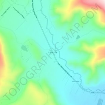
Name: Cleveland topographic map, elevation, terrain.
Location: Cleveland, Mora County, New Mexico, 87715, United States (35.97332 -105.39068 36.01332 -105.35068)
Average elevation: 2,312 m
Minimum elevation: 2,205 m
Maximum elevation: 2,616 m
Thank you for supporting this site ❤️
Make a donation
Make a donation
Other topographic maps
Click on a map to view its topography, its elevation and its terrain.