
Thank you for supporting this site ❤️
Make a donation
Make a donation
Kendal topographic map
Click on the map to display elevation.
Thank you for supporting this site ❤️
Make a donation
Make a donation
About this map
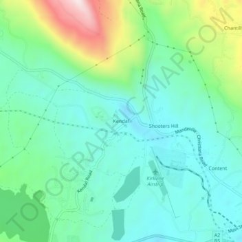
Name: Kendal topographic map, elevation, terrain.
Location: Kendal, Manchester, Middlesex County, Jamaica (18.06873 -77.50458 18.10873 -77.46458)
Average elevation: 504 m
Minimum elevation: 351 m
Maximum elevation: 943 m
Thank you for supporting this site ❤️
Make a donation
Make a donation
Other topographic maps
Click on a map to view its topography, its elevation and its terrain.