
Thank you for supporting this site ❤️
Make a donation
Make a donation
Lac des Sables topographic map
Click on the map to display elevation.
Thank you for supporting this site ❤️
Make a donation
Make a donation
About this map
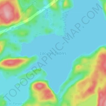
Name: Lac des Sables topographic map, elevation, terrain.
Average elevation: 155 m
Minimum elevation: 119 m
Maximum elevation: 274 m
Thank you for supporting this site ❤️
Make a donation
Make a donation
Other topographic maps
Click on a map to view its topography, its elevation and its terrain.
Lac des Grandes Bergeronnes
Canada > Québec > La Haute-Côte-Nord > Les Bergeronnes
Average elevation: 263 m
Rivière des Grandes Bergeronnes
Canada > Québec > La Haute-Côte-Nord > Les Bergeronnes
Average elevation: 27 m