
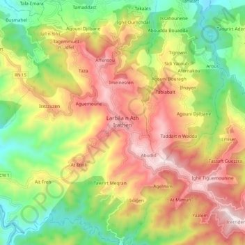
Larbaa N'Aït Irathen topographic map
Interactive map
Click on the map to display elevation.
About this map
Name: Larbaa N'Aït Irathen topographic map, elevation, terrain.
Average elevation: 578 m
Minimum elevation: 154 m
Maximum elevation: 1,051 m
L'économie locale est essentiellement agricole, elle repose surtout sur l'arboriculture de montagne. L'olivier et le figuier sont sources de revenus non négligeables, même si leur culture est en recul. À côté, le cerisier, introduit sous la colonisation par bouturage, a trouvé un climat et une altitude propices à sa culture et son développement, surtout sur les versants Nord de la confédération.
Other topographic maps
Click on a map to view its topography, its elevation and its terrain.
Aït Atelli
Algérie > Tizi Ouzou > Daïra Larbaa N'Aït Irathen > Larbaa N'Aït Irathen
Aït Atelli, Larbaa N'Aït Irathen, Daïra Larbaa N'Aït Irathen, Tizi Ouzou, Algérie
Average elevation: 571 m
Barrage de Taksebt
Algérie > Tizi Ouzou > Daïra Larbaa N'Aït Irathen > Irdjen > Aït Halli
Barrage de Taksebt, Aït Halli, Irdjen, Daïra Larbaa N'Aït Irathen, Tizi Ouzou, Algérie
Average elevation: 353 m
Irdjen
Algérie > Tizi Ouzou > Daïra Larbaa N'Aït Irathen
Irdjen, Daïra Larbaa N'Aït Irathen, Tizi Ouzou, Algérie
Average elevation: 300 m
Bousmahel
Algérie > Tizi Ouzou > Daïra Larbaa N'Aït Irathen > Irdjen
Bousmahel, Irdjen, Daïra Larbaa N'Aït Irathen, Tizi Ouzou, 15001, Algérie
Average elevation: 359 m
Aït Yacoub
Algérie > Tizi Ouzou > Daïra Larbaa N'Aït Irathen > Irdjen > Aït Halli
Aït Yacoub, Aït Halli, Irdjen, Daïra Larbaa N'Aït Irathen, Tizi Ouzou, 15001, Algérie
Average elevation: 391 m