
Nilüfer topographic map
Interactive map
Click on the map to display elevation.
About this map
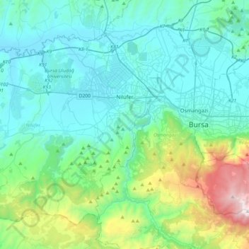
Name: Nilüfer topographic map, elevation, terrain.
Location: Nilüfer, Bursa, Marmara Region, Turkey (40.06413 28.63719 40.30149 29.00957)
Average elevation: 424 m
Minimum elevation: 48 m
Maximum elevation: 2,135 m
Other topographic maps
Click on a map to view its topography, its elevation and its terrain.
Atatürk Kent Ormanı
Atatürk Kent Ormanı, Gümüştepe Mahallesi, Nilüfer, Bursa, Marmara Region, Turkey
Average elevation: 238 m
Barış Mahallesi
Barış Mahallesi, Nilüfer, Bursa, Marmara Region, Turkey
Average elevation: 120 m