
Barış Mahallesi topographic map
Interactive map
Click on the map to display elevation.
About this map
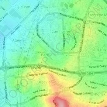
Name: Barış Mahallesi topographic map, elevation, terrain.
Location: Barış Mahallesi, Nilüfer, Bursa, Marmara Region, Turkey (40.21148 28.95923 40.22121 28.97760)
Average elevation: 120 m
Minimum elevation: 70 m
Maximum elevation: 218 m
Other topographic maps
Click on a map to view its topography, its elevation and its terrain.