
Wheelertown topographic map
Interactive map
Click on the map to display elevation.
About this map
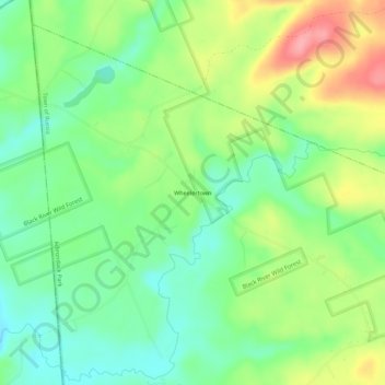
Name: Wheelertown topographic map, elevation, terrain.
Average elevation: 424 m
Minimum elevation: 384 m
Maximum elevation: 486 m
Other topographic maps
Click on a map to view its topography, its elevation and its terrain.
Trenton Falls - Main Dam
United States > New York > Herkimer County > Town of Russia
Trenton Falls - Main Dam, Town of Russia, Herkimer County, New York, 13435, United States
Average elevation: 321 m
Northwood
United States > New York > Herkimer County > Town of Russia
Northwood, Town of Russia, Herkimer County, New York, United States
Average elevation: 392 m
Gravesville
United States > New York > Herkimer County > Town of Russia
Gravesville, Town of Russia, Herkimer County, New York, United States
Average elevation: 280 m
Grant
United States > New York > Herkimer County > Town of Russia
Grant, Town of Russia, Herkimer County, New York, United States
Average elevation: 394 m