
Thank you for supporting this site ❤️
Make a donation
Make a donation
Alexandria topographic map
Click on the map to display elevation.
Thank you for supporting this site ❤️
Make a donation
Make a donation
About this map
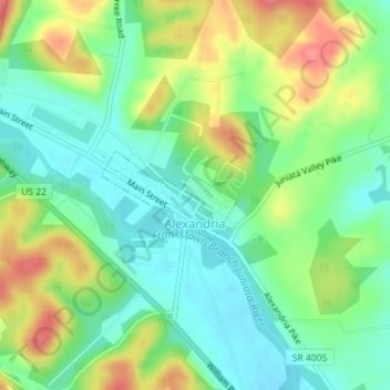
Name: Alexandria topographic map, elevation, terrain.
Location: Alexandria, Huntingdon County, Pennsylvania, United States (40.55530 -78.10632 40.56147 -78.09397)
Average elevation: 238 m
Minimum elevation: 209 m
Maximum elevation: 284 m
Thank you for supporting this site ❤️
Make a donation
Make a donation
Other topographic maps
Click on a map to view its topography, its elevation and its terrain.
Cold Spring
United States > Pennsylvania > Huntingdon County > Oneida Township
Average elevation: 256 m
Pemberton
United States > Pennsylvania > Huntingdon County > Spruce Creek Township
Average elevation: 309 m
Pennsylvania Furnace
United States > Pennsylvania > Huntingdon County > Franklin Township
Average elevation: 363 m