
Make a donation
Bochum topographic map
Click on the map to display elevation.
Make a donation
Bochum
The city lies on the low rolling hills of Bochum land ridge (Bochumer Landrücken), part of the Ruhrhöhen (highest elevations) between the Ruhr and Emscher rivers at the border of the southern and northern Ruhr coal region. The highest point of the city is at Kemnader Straße (Kemnader Street) in Stiepel at 196 metres (643 ft) above sea level; the lowest point is 43 metres (141 ft) at the Blumenkamp in Hordel.
Make a donation
About this map
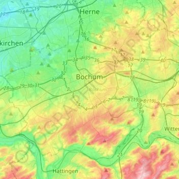
Name: Bochum topographic map, elevation, terrain.
Location: Bochum, North Rhine-Westphalia, Germany (51.41050 7.10208 51.53137 7.34933)
Average elevation: 99 m
Minimum elevation: 29 m
Maximum elevation: 226 m
Make a donation
Other topographic maps
Click on a map to view its topography, its elevation and its terrain.
Make a donation
Plettenburg
Germany > North Rhine-Westphalia > Rheinisch-Bergischer Kreis > Wermelskirchen > Grunewald
Average elevation: 231 m