
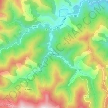
Le Soulies topographic map
Interactive map
Click on the map to display elevation.
About this map
Name: Le Soulies topographic map, elevation, terrain.
Average elevation: 597 m
Minimum elevation: 351 m
Maximum elevation: 933 m
Other topographic maps
Click on a map to view its topography, its elevation and its terrain.
La Hierle
France > Occitanie > Gard > Les Plantiers
La Hierle, Les Plantiers, Le Vigan, Gard, Occitanie, France métropolitaine, 30122, France
Average elevation: 608 m
Faveyrolles
France > Occitanie > Gard > Les Plantiers
Faveyrolles, Les Plantiers, Le Vigan, Gard, Occitanie, France métropolitaine, 30122, France
Average elevation: 691 m
Les Plantiers
France > Occitanie > Gard > Les Plantiers > Les Plantiers
Les Plantiers, Le Vigan, Gard, Occitanie, France métropolitaine, 30122, France
Average elevation: 569 m