
Ribeira de Colares topographic map
Interactive map
Click on the map to display elevation.
About this map
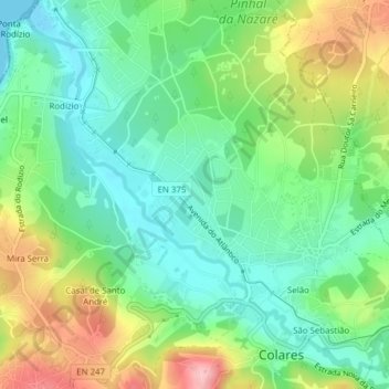
Name: Ribeira de Colares topographic map, elevation, terrain.
Location: Ribeira de Colares, Colares, Sintra, Lisboa, Portugal (38.79781 -9.47130 38.82520 -9.43284)
Average elevation: 57 m
Minimum elevation: 0 m
Maximum elevation: 163 m
Other topographic maps
Click on a map to view its topography, its elevation and its terrain.