
Meekwap Lake topographic map
Interactive map
Click on the map to display elevation.
About this map
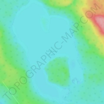
Name: Meekwap Lake topographic map, elevation, terrain.
Location: Meekwap Lake, Division No. 18, Alberta, Canada (54.63125 -116.65900 54.68600 -116.59450)
Average elevation: 822 m
Minimum elevation: 801 m
Maximum elevation: 912 m
Other topographic maps
Click on a map to view its topography, its elevation and its terrain.
Two Lakes
Canada > Alberta > Division No. 18
Two Lakes, Division No. 18, Alberta, Canada
Average elevation: 1,255 m
Lingrell Lake
Canada > Alberta > Division No. 18
Lingrell Lake, Division No. 18, Alberta, Canada
Average elevation: 991 m
Big Mountain Creek Provincial Recreation Area
Canada > Alberta > Division No. 18
Big Mountain Creek Provincial Recreation Area, Bighorn Highway, Division No. 18, Alberta, Canada
Average elevation: 657 m
Hamlet of Grande Cache
Canada > Alberta > Division No. 18
Hamlet of Grande Cache, Division No. 18, Alberta, T0E 0Y0, Canada
Average elevation: 1,154 m