
Nauendorf topographic map
Interactive map
Click on the map to display elevation.
About this map
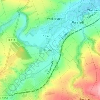
Name: Nauendorf topographic map, elevation, terrain.
Average elevation: 183 m
Minimum elevation: 138 m
Maximum elevation: 267 m
Other topographic maps
Click on a map to view its topography, its elevation and its terrain.
Lohteich
Deutschland > Thüringen > Landkreis Weimarer Land > Apolda > Herressen
Lohteich, Herressen, Apolda, Landkreis Weimarer Land, Thüringen, 99510, Deutschland
Average elevation: 198 m
Oberroßla
Deutschland > Thüringen > Landkreis Weimarer Land > Apolda > Oberroßla
Oberroßla, Apolda, Landkreis Weimarer Land, Thüringen, 99510, Deutschland
Average elevation: 208 m