
Webbekom topographic map
Interactive map
Click on the map to display elevation.
About this map
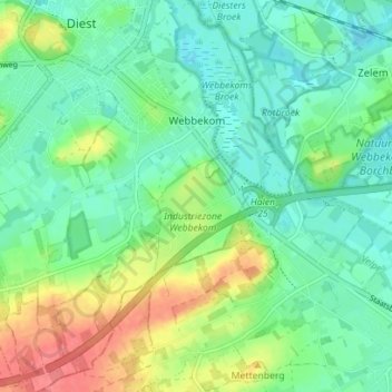
Name: Webbekom topographic map, elevation, terrain.
Location: Webbekom, Diest, Louvain, Brabant flamand, Belgique (50.94277 5.02638 50.98697 5.08516)
Average elevation: 33 m
Minimum elevation: 13 m
Maximum elevation: 75 m
Other topographic maps
Click on a map to view its topography, its elevation and its terrain.
Schaffen
Belgique > Brabant flamand > Louvain > Diest
Schaffen, Diest, Louvain, Brabant flamand, Flandre, 3290, Belgique
Average elevation: 28 m