
Village of Warwick topographic map
Interactive map
Click on the map to display elevation.
About this map
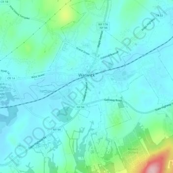
Name: Village of Warwick topographic map, elevation, terrain.
Average elevation: 187 m
Minimum elevation: 150 m
Maximum elevation: 371 m
Other topographic maps
Click on a map to view its topography, its elevation and its terrain.
Village of Florida
United States > New York > Orange County > Town of Warwick
Village of Florida, Town of Warwick, Orange County, New York, 10921, United States
Average elevation: 150 m
Bellvale
United States > New York > Orange County > Town of Warwick
Bellvale, Town of Warwick, Orange County, New York, 10912, United States
Average elevation: 226 m
Sterling Forest
United States > New York > Orange County > Town of Warwick
Sterling Forest, Town of Warwick, Orange County, New York, 10979, United States
Average elevation: 252 m