
Cashion topographic map
Interactive map
Click on the map to display elevation.
About this map
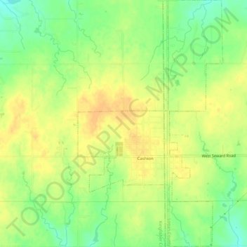
Name: Cashion topographic map, elevation, terrain.
Location: Cashion, Kingfisher County, Oklahoma, 73016, United States (35.78390 -97.69206 35.82351 -97.66335)
Average elevation: 339 m
Minimum elevation: 320 m
Maximum elevation: 351 m
Other topographic maps
Click on a map to view its topography, its elevation and its terrain.
Kingfisher
United States > Oklahoma > Kingfisher County
Kingfisher, Kingfisher County, Oklahoma, 73750, United States
Average elevation: 329 m
Omega
United States > Oklahoma > Kingfisher County
Omega, Kingfisher County, Oklahoma, 73764, United States
Average elevation: 367 m
Dover
United States > Oklahoma > Kingfisher County
Dover, Kingfisher County, Oklahoma, 73734, United States
Average elevation: 322 m
Okarche
United States > Oklahoma > Kingfisher County
Okarche, Kingfisher County, Oklahoma, United States
Average elevation: 374 m
Loyal
United States > Oklahoma > Kingfisher County
Loyal, Kingfisher County, Oklahoma, United States
Average elevation: 344 m