
Hines topographic map
Interactive map
Click on the map to display elevation.
About this map
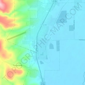
Name: Hines topographic map, elevation, terrain.
Location: Hines, Harney County, Oregon, 97738, United States (43.53457 -119.09976 43.57612 -119.06490)
Average elevation: 1,296 m
Minimum elevation: 1,258 m
Maximum elevation: 1,457 m
Other topographic maps
Click on a map to view its topography, its elevation and its terrain.
Chickahominy Reservoir
United States > Oregon > Harney County
Chickahominy Reservoir, Harney County, Oregon, United States
Average elevation: 1,310 m
Riley
United States > Oregon > Harney County
Riley, Harney County, Oregon, United States
Average elevation: 1,295 m
Crane
United States > Oregon > Harney County
Crane, Harney County, Oregon, 97732, United States
Average elevation: 1,289 m
Burns
United States > Oregon > Harney County
Burns, Harney County, Oregon, United States
Average elevation: 1,271 m