
Thank you for supporting this site ❤️
Make a donation
Make a donation
Lagarde-Enval topographic map
Click on the map to display elevation.
Thank you for supporting this site ❤️
Make a donation
Make a donation
About this map
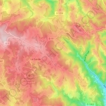
Name: Lagarde-Enval topographic map, elevation, terrain.
Average elevation: 447 m
Minimum elevation: 246 m
Maximum elevation: 569 m
Thank you for supporting this site ❤️
Make a donation
Make a donation
Other topographic maps
Click on a map to view its topography, its elevation and its terrain.
Le Bois de Breuil
France > Nouvelle-Aquitaine > Corrèze > Lagarde-Marc-la-Tour
Average elevation: 441 m
Thank you for supporting this site ❤️
Make a donation
Make a donation
La Chapeloune
France > Nouvelle-Aquitaine > Corrèze > Lagarde-Marc-la-Tour > La Méchaussie
Average elevation: 490 m
Soulage
France > Nouvelle-Aquitaine > Corrèze > Lagarde-Marc-la-Tour > Soulage
Average elevation: 419 m
Thank you for supporting this site ❤️
Make a donation
Make a donation