
West Taghkanic topographic map
Interactive map
Click on the map to display elevation.
About this map
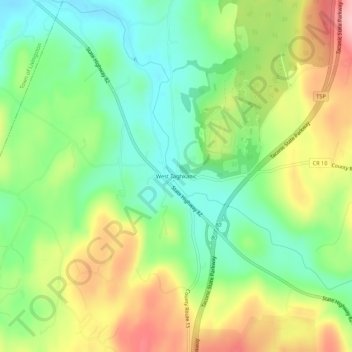
Name: West Taghkanic topographic map, elevation, terrain.
Average elevation: 147 m
Minimum elevation: 81 m
Maximum elevation: 242 m
Other topographic maps
Click on a map to view its topography, its elevation and its terrain.
New Forge
United States > New York > Columbia County > Town of Taghkanic
New Forge, Town of Taghkanic, Columbia County, New York, 12502, United States
Average elevation: 193 m
East Taghkanic
United States > New York > Columbia County > Town of Taghkanic
East Taghkanic, Town of Taghkanic, Columbia County, New York, 12521, United States
Average elevation: 200 m