
Leemhorst topographic map
Interactive map
Click on the map to display elevation.
About this map
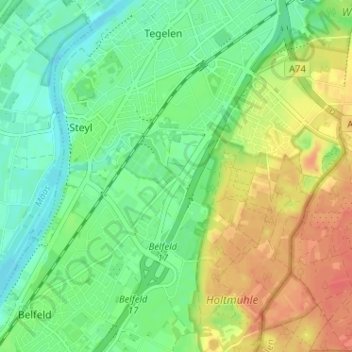
Name: Leemhorst topographic map, elevation, terrain.
Average elevation: 30 m
Minimum elevation: 11 m
Maximum elevation: 56 m
Other topographic maps
Click on a map to view its topography, its elevation and its terrain.
Maasveld I
Nederland > Limburg > Tegelen > Maasveld I
Maasveld I, Tegelen, Venlo, Limburg, Nederland, 5931SG, Nederland
Average elevation: 23 m
Maasveld II
Nederland > Limburg > Tegelen > Maasveld II
Maasveld II, Tegelen, Venlo, Limburg, Nederland, 5931TJ, Nederland
Average elevation: 24 m