
Thank you for supporting this site ❤️
Make a donation
Make a donation
Bishkek topographic map
Click on the map to display elevation.
Thank you for supporting this site ❤️
Make a donation
Make a donation
Bishkek
Bishkek is situated at an altitude of about 800 metres (2,600 ft), just off the northern fringe of the Kyrgyz Ala-Too Range, an extension of the Tian Shan mountain range. These mountains rise to a height of 4,895 metres (16,060 ft). North of the city, a fertile and gently undulating steppe extends far north into neighbouring Kazakhstan. The river Chüy drains most of the area. Bishkek is connected to the Turkestan–Siberia Railway by a spur line.
Thank you for supporting this site ❤️
Make a donation
Make a donation
About this map
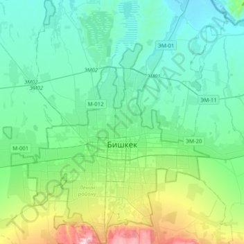
Name: Bishkek topographic map, elevation, terrain.
Location: Bishkek, Kyrgyzstan (42.78737 74.49361 42.97190 74.71776)
Average elevation: 777 m
Minimum elevation: 646 m
Maximum elevation: 1,272 m
Thank you for supporting this site ❤️
Make a donation
Make a donation