
Thank you for supporting this site ❤️
Make a donation
Make a donation
Marangattupilly topographic map
Click on the map to display elevation.
Thank you for supporting this site ❤️
Make a donation
Make a donation
About this map
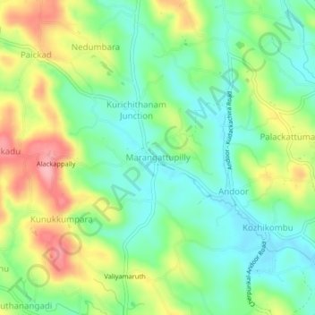
Name: Marangattupilly topographic map, elevation, terrain.
Location: Marangattupilly, Meenachil, Kottayam, Kerala, 686635, India (9.72232 76.59216 9.76232 76.63216)
Average elevation: 63 m
Minimum elevation: 13 m
Maximum elevation: 145 m
Thank you for supporting this site ❤️
Make a donation
Make a donation
Other topographic maps
Click on a map to view its topography, its elevation and its terrain.