
Janjheli topographic map
Interactive map
Click on the map to display elevation.
About this map
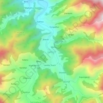
Name: Janjheli topographic map, elevation, terrain.
Location: Janjheli, Thunag, Mandi, Himachal Pradesh, 175047, India (31.49678 77.20141 31.53678 77.24141)
Average elevation: 2,282 m
Minimum elevation: 1,960 m
Maximum elevation: 2,787 m
Other topographic maps
Click on a map to view its topography, its elevation and its terrain.
Chhatri
India > Himachal Pradesh > Thunag
Chhatri, Thunag, Mandi District, Himachal Pradesh, India
Average elevation: 2,079 m
Dhawas
India > Himachal Pradesh > Thunag
Dhawas, Thunag, Mandi District, Himachal Pradesh, India
Average elevation: 2,404 m
Mathyani
India > Himachal Pradesh > Thunag > Baksaid
Mathyani, Baksaid, Thunag, Mandi District, Himachal Pradesh, 175039, India
Average elevation: 2,073 m