
Isla Chaffers topographic map
Interactive map
Click on the map to display elevation.
About this map
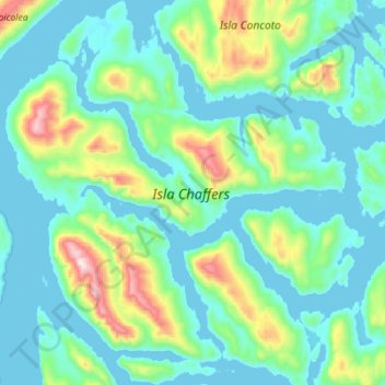
Name: Isla Chaffers topographic map, elevation, terrain.
Average elevation: 150 m
Minimum elevation: -2 m
Maximum elevation: 842 m
Other topographic maps
Click on a map to view its topography, its elevation and its terrain.
Río Pascua
Chile > Región Aysén del General Carlos Ibáñez del Campo > Cisnes
Río Pascua, Cisnes, Provincia de Aysén, Región Aysén del General Carlos Ibáñez del Campo, Chile
Average elevation: 100 m
Isla Jorge
Chile > Región Aysén del General Carlos Ibáñez del Campo > Cisnes
Isla Jorge, Cisnes, Provincia de Aysén, Región Aysén del General Carlos Ibáñez del Campo, Chile
Average elevation: 140 m