
Thank you for supporting this site ❤️
Make a donation
Make a donation
Tumbabiro topographic map
Click on the map to display elevation.
Thank you for supporting this site ❤️
Make a donation
Make a donation
About this map
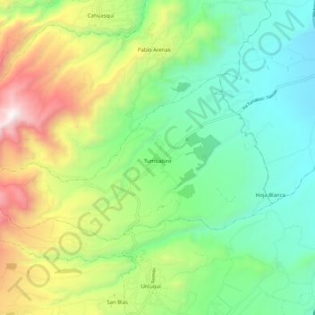
Name: Tumbabiro topographic map, elevation, terrain.
Location: Tumbabiro, San Miguel de Urcuquí, Imbabura, Ecuador (0.43335 -78.26277 0.49212 -78.15126)
Average elevation: 2,191 m
Minimum elevation: 1,618 m
Maximum elevation: 3,327 m
Thank you for supporting this site ❤️
Make a donation
Make a donation
Other topographic maps
Click on a map to view its topography, its elevation and its terrain.
Iruguincho
Ecuador > Imbabura > San Miguel de Urcuquí > San Blas > Iruguincho
Average elevation: 2,516 m