
Independence topographic map
Interactive map
Click on the map to display elevation.
About this map
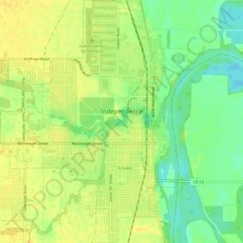
Name: Independence topographic map, elevation, terrain.
Location: Independence, Polk County, Oregon, 97351, United States (44.83640 -123.21662 44.87244 -123.17643)
Average elevation: 50 m
Minimum elevation: 35 m
Maximum elevation: 58 m
Other topographic maps
Click on a map to view its topography, its elevation and its terrain.
Willamette River
United States > Oregon > Polk County
Willamette River, Polk County, Oregon, United States
Average elevation: 72 m
Dallas
United States > Oregon > Polk County
Dallas, Polk County, Oregon, 97338, United States
Average elevation: 119 m
Monmouth
United States > Oregon > Polk County
Monmouth, Polk County, Oregon, United States
Average elevation: 58 m
Buena Vista
United States > Oregon > Polk County
Buena Vista, Polk County, Oregon, United States
Average elevation: 67 m
Aaron Mercer Reservoir
United States > Oregon > Polk County
Aaron Mercer Reservoir, Polk County, Oregon, United States
Average elevation: 367 m
Grand Ronde
United States > Oregon > Polk County > Grand Ronde
Grand Ronde, Polk County, Oregon, United States
Average elevation: 132 m