
Thank you for supporting this site ❤️
Make a donation
Make a donation
Saint Ignace topographic map
Click on the map to display elevation.
Thank you for supporting this site ❤️
Make a donation
Make a donation
About this map
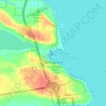
Name: Saint Ignace topographic map, elevation, terrain.
Location: Saint Ignace, Mackinac County, Michigan, United States (45.84858 -84.74219 45.89715 -84.70093)
Average elevation: 189 m
Minimum elevation: 173 m
Maximum elevation: 223 m
Thank you for supporting this site ❤️
Make a donation
Make a donation
Other topographic maps
Click on a map to view its topography, its elevation and its terrain.
Crossville Lake
United States > Michigan > Mackinac County > Hendricks Township
Average elevation: 263 m
Thank you for supporting this site ❤️
Make a donation
Make a donation
Thank you for supporting this site ❤️
Make a donation
Make a donation