
Thank you for supporting this site ❤️
Make a donation
Make a donation
Porco topographic map
Click on the map to display elevation.
Thank you for supporting this site ❤️
Make a donation
Make a donation
About this map
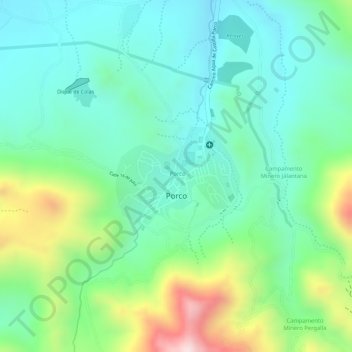
Name: Porco topographic map, elevation, terrain.
Location: Porco, Municipio Porco, Antonio Quijarro, Potosí, Bolivia (-19.80159 -65.99276 -19.79403 -65.98258)
Average elevation: 4,153 m
Minimum elevation: 4,023 m
Maximum elevation: 4,445 m
Thank you for supporting this site ❤️
Make a donation
Make a donation
Other topographic maps
Click on a map to view its topography, its elevation and its terrain.
Aguas Termales
Bolivia > Potosí > Antonio Quijarro > Municipio Porco > Visigza
Average elevation: 3,894 m
Thank you for supporting this site ❤️
Make a donation
Make a donation