
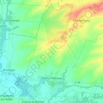
Plancy-l'Abbaye topographic map
Interactive map
Click on the map to display elevation.
About this map
Name: Plancy-l'Abbaye topographic map, elevation, terrain.
Average elevation: 94 m
Minimum elevation: 74 m
Maximum elevation: 142 m
Other topographic maps
Click on a map to view its topography, its elevation and its terrain.
Avant-lès-Marcilly
Avant-lès-Marcilly, Nogent-sur-Seine, Aube, Grand Est, Metropolitaans Frankrijk, 10400, Frankrijk
Average elevation: 126 m
La Rothière
La Rothière, Bar-sur-Aube, Aube, Grand Est, Metropolitaans Frankrijk, 10500, Frankrijk
Average elevation: 140 m
Magnicourt
Magnicourt, Bar-sur-Aube, Aube, Grand Est, Metropolitaans Frankrijk, 10240, Frankrijk
Average elevation: 112 m
Les Granges
Les Granges, Troyes, Aube, Grand Est, Metropolitaans Frankrijk, 10210, Frankrijk
Average elevation: 144 m